Fishing forecasts with sonar-style visuals for Lithuanian anglers
Kibimo radaras, developed by Kibimo radaras, helps anglers plan trips by predicting fish activity using meteorological and lunar inputs. The app calculates real-time bite probability and displays a 24-hour sonar-style activity overview to highlight promising time windows. It tracks pressure trends, temperature, wind direction, and moon phase while offering species-specific filters and a manual mode. Recreational and professional anglers in Lithuania gain a data-focused planning tool for improving outing timing and site selection.
What the app does for daily trip planning
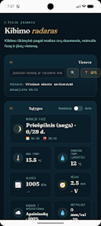
The app produces a localized, time-based bite forecast that anglers can consult before leaving home. It combines weather data, moon phases, and solar cycles to calculate a bite probability for the next 24 hours, presented on a sonar-style screen so users can spot high-activity windows at a glance. This makes it useful for deciding whether to fish in the morning, afternoon, or evening on a given date.
How location and offline use suit remote outings
The app can detect position automatically via GPS and also accepts manual searches for specific water bodies, which helps when scouting remote sites without reliable reception. Manual Mode lets anglers enter environmental conditions by hand to generate forecasts while offline or to test hypothetical scenarios. These options support field use on lakes or rivers where cellular data is intermittent.
How the interface and species filters support practical decisions
The sonar-style visualization provides an immediate 24-hour overview that highlights time windows, and species-specific filters let users switch forecasts between predatory and peaceful fish. That design aims to match common angling questions, such as when pike versus carp are likelier to bite. The layout emphasizes quick scanning, so a user can interpret a plan during a short pre-trip routine.
Accuracy, inputs, and what drives the forecast
The app bases its bite probability on concrete environmental inputs: air temperature, atmospheric pressure trends in hPa, wind speed and direction, cloud cover, precipitation, and lunar phase. Weekly recommendations point out the best dates and time windows according to those signals. This method ties forecast quality directly to the availability and freshness of local weather and solar/lunar data.
To sum up, a practical planning tool for local anglers
To sum up, the app is a pragmatic option for anglers in Lithuania who want data-based timing for fishing trips. It benefits users who value time-of-day guidance and species-specific cues; less suitable users include those needing broad international coverage beyond the app's localized focus. A practical tip: use GPS detection before leaving and save manual settings for low-coverage spots to preserve forecast usefulness.